Home
Card Loop, 23 June, 2024
Ten hikers met for the Card Canyon loop: Ralph, Brent L., Brent J., Joan, Susan, Kamren, Dick, Jane, Dave W., and Dave P. (leader). One spot on the dirt road to the trailhead had holes and loose rocks; the two trucks made it without a problem and the Outback finally did after three tries.
The hike up the East fork was cool and lovely, and we frequently went through waist-high plants and flowers. We turned off the trail above a small beaver pond to follow a short-cut route we have used before, but at first we just waded westward through the field of bluebells. We came upon a wildlife track which made the going easier, and followed it to another beaver pond and a 2-track road, which led up to the meadow between the forks. We had to compromise on a place to have lunch because flying insects were around and we knew they would get us in the trees. It was sunny and warm, but fortunately breezy, so we opted to sit in the open.
We were surprised that the meadow was not a sea of yellow flowers of mule ears. There has been two unusual weather conditions that might explain why—very little rain in May and June, and a freeze on June 18. But there is another interesting and rare feature to this meadow—it has small round pebbles called oncoids. These are formed like stromatolites by biofilms that cause precipitation of limestone. Concentric layers of limestone can be seen when the pebbles are broken open. But instead of growing on the sea floor or lake bottom, oncoids are rolled in shallow water. The geological map labels this area the basal unit of the Wasatch Formation, which was deposited about 50 million years ago. The oncoids tell us that this ridge-top meadow was a lake back then.
The trail down the West fork is used by motorcycles, which made for difficult footing due to a V-shaped track and loose rocks. The trail went through a few rock-fields that seemed impossible for motorcycles. In the archery range we saw a family out for some practice shooting at big game "3-D" targets. It was a good hike but steep, and a hot afternoon, so everyone was pretty tired at the end.
Trip Summary:
- 10 Cache Hikers: Ralph, Brent L., Brent J., Joan, Susan, Kamren, Dick, Jane, Dave W., and Dave P. (leader)
- Drove 10 miles to Card Canyon and another 3/4 mile over a rough road to the gate
- Started hiking 8:30, lunch 11:55 - 12:15, back at the gate 2:00
- Clear skies, temperature became very hot, from 69 ºF at the start to 94 ºF at the end, with an occasional welcome breeze
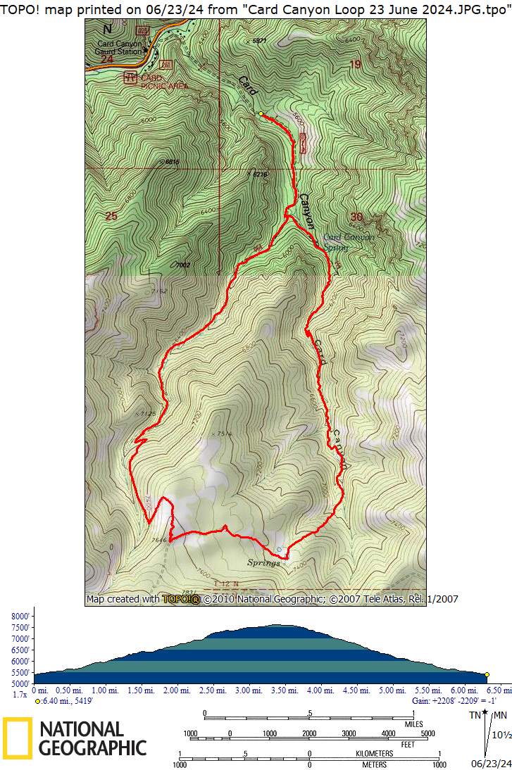
- Hiked about 6.4 miles with 2200 feet of ascent
Thanks
to Dave P for the narrative and photos, Susan for
photos, and Ralph and Dave W for photos and GPS data.
 |
|||
| Cache Hikers near the archery range | |||
 |
 |
||
| There is an archery range where Card
Canyon splits (about 2/3 mile from the start) |
|||
 |
 |
||
| Snow on the main ridge of the Bear
River Range to the north |
Hikers admired the numerous
wildflowers along the trail |
||
 |
|||
| A "standing stone" about 1.5 miles up Card Canyon East | |||
 |
 |
||
| Traveling off-trail through a field of
bluebells |
Beaver pond between Card East and Card
West |
||
 |
|||
| Lunch in a Card West meadow | |||
 |
 |
||
| No mules ear flowers on upper Card
West! |
Oncoids are scattered on the surface |
||
 |
 |
||
| Sweet pea |
Larkspur |
||
 |
 |
||
| Scarlet gilia |
Penstemon |
||
 |
 |
||
| Ninebark |
Wild strawberry |
||
 |
 |
||
| Thimbleberry |
Mountain lover |
||
 |
 |
||
| Bluebells |
Snowbrush |
||
 |
 |
||
| Wild geranium |
Columbine |
||
 |
 |
||
| Bigleaf balsamroot |
Solomon's seal |
||
 |
|||
| Turkey vultures | |||
 |
|||
|
Our GPS track shows about 6.4 miles
and 2200
feet
of ascent.
You can look at our route using Google Earth
or download our GPS
file.
|
|||