Home
Franklin Basin Ski/Snowshoe, 7 March, 2021
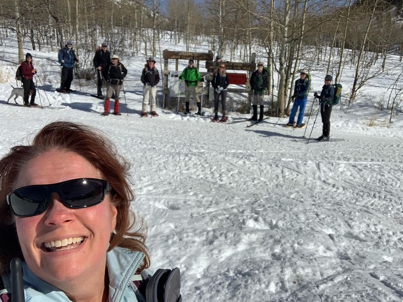
Twelve
hikers came out for the Franklin Basin winter outing: Dave
W, Dave P, David, Deanna, Teresa, Michelle, Chris, Keith,
Laurel, Brent, Becky, Dan (the leader), as well as Jasper
the dog. Dave W, Deanna, and Teresa used skis and the rest
on snowshoes. We arrived at the trailhead at about
10:45 a.m. with warm, sunny conditions.
We
took the usual route up the road and, taking a right,
across the meadow tracked with snow machine ruts. The
route took us up through conifer forest, along the edge of
another meadow and continued eventually to an aspen
dominated forest. Although we usually stop for lunch on
the way up the hill, we decided to continue to the ridge
before our lunch break. Becky spent some time in
her hammock while the rest of us sat nearby on the snow.
After
a relaxing break the group followed the ridge down through
mature conifer and aspen forest with soft snow, then out
into an open section with views of the backside of Beaver
Mountain. We came off the ridge to the right and down a
steeper section through the woods, then eventually out
into the open meadows while listening to the whine of snow
machines. We reached the cars at about 3 p.m. and back to
Logan before 4 p.m.
Trip Summary:
- Participants:
Skiers Deanna, Dave W. and Teresa, snowshoers Brent,
Chris, Keith, David, Dan, Dave P., Becky, Laurel and
Michelle, and a dog, Jasper
- Drove 25
miles to the Franklin Basin Winter Trailhead
- Started out
about 10:50, with lunch from 12:50 - 1:30, and back at
the trailhead at 3:00
- Warm
temperatures, clear skies, calm winds and soft snow
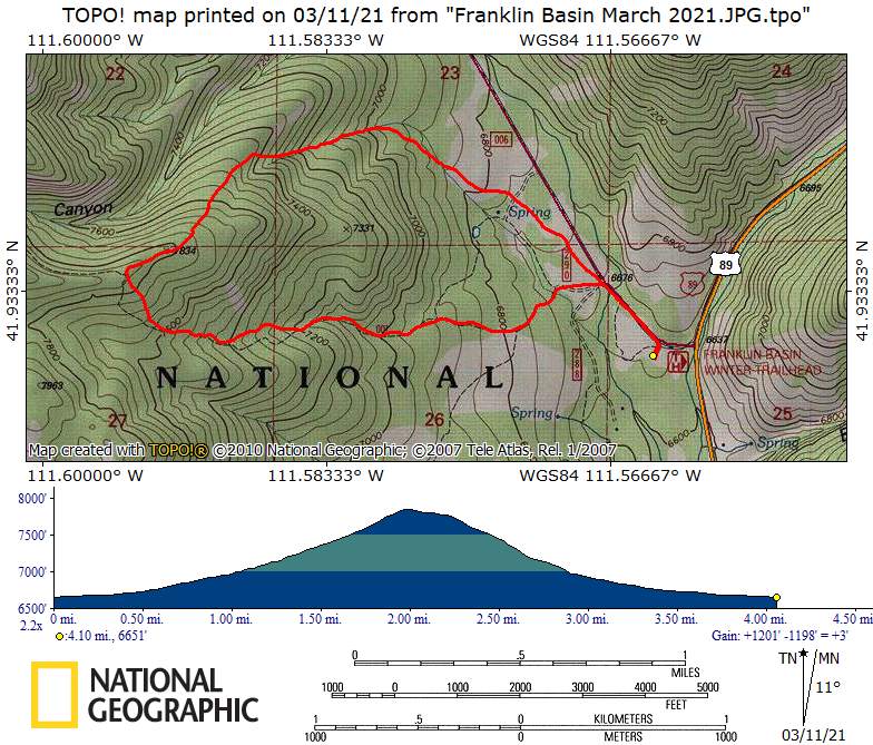
- Traveled 4.1
miles with 1200 feet of elevation gain
Thanks
to Dan for the narrative, photos and GPS data, and
Dave W. and Michelle for photos.
 |
|
| The Franklin
Basin Winter Trailhead |
|
 |
|
| Climbing a
steep slope (over 20% grade) to the ridge |
|
 |
 |
| Our lunch spot on the ridge |
Becky brought a hammock! |
 |
|
| Descending a
ridge toward Franklin Basin |
|
 |
|
|
Our GPS track shows about 4.1 miles
and 1200 feet of ascent and descent.
You can look at our route using Google Earth or download our GPS file. |
|