
Home
Wilderness Peak, 7 September, 2025
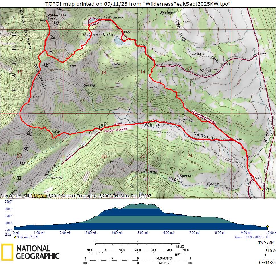
Nine hikers met and departed from Logan and were joined by one more at the Franklin Basin turnoff in Logan Canyon. Roads were quite wet with plenty of puddles, evidence of much more rain in the mountains than was received in the valley. We were saved from the recent summer dust but started with wet pants. Leaving the parking spots at 9:10, we first passed the gate barring vehicular access to White Canyon Road and walked right across the Logan River. The White Canyon trail, though braided with cow paths, was clear and in relatively good shape for the whole time that we were on it. After about two miles, we branched onto the route of a trail mapped as Crooked Creek. Overall, this trail does not remain visible on the ground; occasionally, cow paths matched the route, but it is impossible to tell whether any of them were actually left from the original trail. The growth suggests that it has been out of use for many decades. Much of the route from here to the ridge was steep but not horrible with good directional planning. The ridgetop offered wonderful views in all directions–south into upper Boss Canyon and toward Doubletop Mountain and Cherry Peak, west toward Gunsight Peak and Oxford Peak, east and north to the far stretches of the Bear River Range and beyond. Patches of rain were observed crossing Cache Valley and reaching the higher parts of the range, mostly bypassing us.
The ridge generally has a weak but unmapped trail from traditional use. A couple ups and downs remained before the peak. Once we reached the main body of the peak, we split between hiking on the very top and a trail just below, eventually settling on the lower for ease. All but one continued all the way to the top. Lunch followed immediately on an easier slope just to the south. We rounded the mountain, following one spur down to the point where a steep trail descends into one of the cirques and out to Gibson Lakes. Along the way, we found a small spring that flows into a sinkhole after only a brief stay above ground, the spring and the sinkhole both easily visible from the trail. Pipes were still visible above ground here and along the way down to the west Gibson Lake. These are believed to have supplied the former Boy Scout camp, Camp Wilderness, with water. This was the only obvious remnant of the camp that was out of operation by the mid 1970s.
The first lake was largely grassy, filled in, and dry from the summer, and the group chose to walk across the lake rather than taking the road. The other lake, much larger around but fairly shallow, formed a beautiful view with the great slabs of Wilderness Peak and the white rock face of the south spur of the mountain. From there, we continued down the road until we came to either a camping spot or the beginning of an old road. We treated it as a road and found a natural route with hints that it once was an actual road leading down into White Canyon and joining a faint yet still mapped road that connects to the mail trail.
It was a wonderful and unique day with interesting and dramatic views and a real wilderness experience. All left thoroughly exhausted but hopefully just as enriched.
Trip Summary:
- Ten
participants: Brent J., Dave P., Ron, Sue,
Ralph, Teresa, Joan, Deanna, Deb, and Kamren (leader)
- Drove 25 miles from Logan to Franklin Basin Road, then 6.5 miles more to White Canyon Creek Road
- Left Smith’s at 8:10, started hiking from the trailhead at 9:10, reached the ridge at 11:45, gathered at the summit at 1:15, lunch north of the summit from 1:20-1:45, reached the cars at 4:40 and back to Smith’s at about 5:30
- Mostly clear skies near us; brief, light rain; clouds and more rain in the distance, mostly to the south; pleasantly cool in the mid 50s
- About 10
miles, 1950 feet of ascent, 7.5 hours.
Thanks
to Kamren for the narrative, photos and GPS data, Dave
P and Deanna for photos, and Ralph for photos and GPS
data.
2025.jpg) |
|||
| Starting out from the White Canyon Road (pointing to Wilderness Peak in the distance) | |||
 |
|||
| Crossing the upper Logan River | |||
 |
|||
| Looking up White Canyon (it gets its name from the white rock formations) toward Wilderness Peak | |||
 |
 |
||
| Climbing to the ridge from White
Canyon |
Hiking up the ridge | ||
 |
 |
||
| On the crest of the main ridge of the
Bear River Range |
About a mile south of Wilderness Peak |
||
 |
|||
| On Wilderness
Peak, at 9460 feet above sea level |
|||
 |
 |
||
| Lunch just below Wilderness Peak |
South, toward Doubletop Mountain and
Cherry Peak |
||
 |
 |
||
| North, to Paris, Bloomington, and
Sherman peaks |
West, toward Cache Valley and
the Oxford Ridge |
||
 |
|||
| East, toward
Gibson Lakes (along our route back to White
Canyon) |
|||
 |
 |
||
| Upper Gibson Lake |
Lower Gibson Lake and Wilderness Peak |
||
 |
 |
||
| Possible bear diggings |
Possible fossil sponge |
||
 |
|||
|
Our GPS track shows about 10 miles
and 1950 feet of total ascent.
You can look at our route using Google Earth
or download our GPS file.
|
|||