
Home
Willow Creek - Cottonwood Loop, 1 June, 2025
Twenty hikers and two dogs gathered at the Smith’s Marketplace parking lot at 8 a.m. to carpool to the Right Hand Fork Trailhead on a beautiful sunny late spring morning.
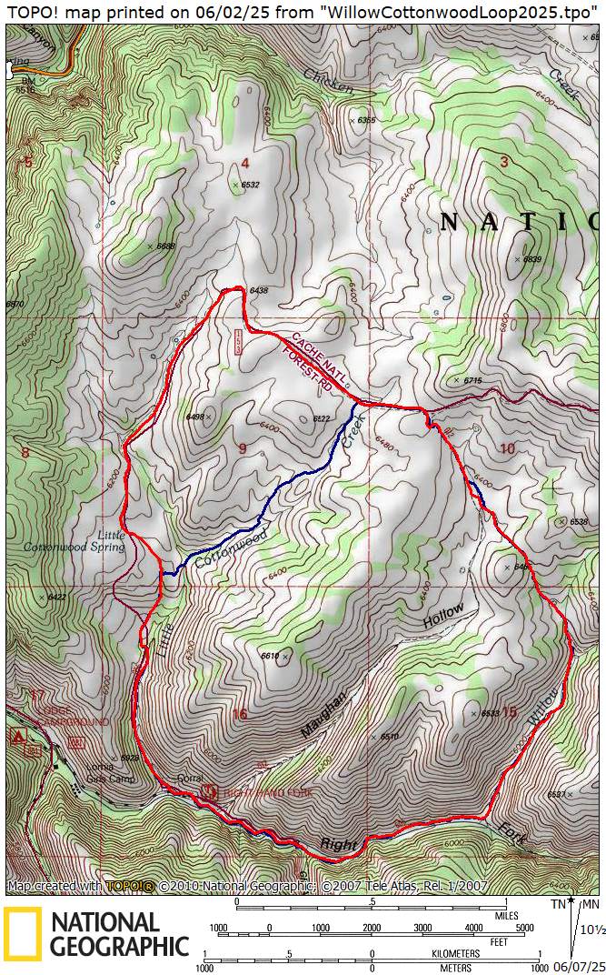
Carpools arrived at the trailhead at about 8:30 a.m. Hikers started on the trail about 8:40 a.m., stopping for a group photo near the trail sign. Hikers continued to the Willow Creek Trail. After about two miles, the group left the trail at a sharp bend/switchback and small stream crossing and headed northwest on an unmarked route.
This path was partly muddy and continued to a small cow pond through abundant wildflowers. From there, the footpath became less well-defined, and the group continued cross-country through a spectacular meadow of full bloom mule-ears (Wyethia amplexicaulis) and then north through a wide-open basin at the head of Maughan Hollow.
This year’s wildflowers included mule-ears, American bistort, mountain dandelion, larkspur, Gray’s biscuitroot, hawthorn & chokecherry shrubs, as well as stands of blue camas (Camassia quamash).
The group proceeded northwest across the basin toward the ridge saddle. The Little Cottonwood jeep road is located just beyond this point. As per tradition, the group stopped for lunch at a shaded rocky spot near some big tooth maples on the ridge near the road at about 11a.m.
Views of Mt Elmer, Beirdneau Peak, Logan Peak, Logan Canyon, and the Cache Valley and Wellsville Mountains are particularly striking at this location. This year, there was some snow remaining on the peaks but not as much as in recent years.
Following lunch, the group continued along the jeep road. Similar to last year, not far down the road, the hikers split into two groups. Nine hikers took an overland cutoff that headed west from the jeep trail. Laurel had previously explored this area. Eleven hikers and the two dogs continued travel on the traditional route.
The two groups reconvened below the stock tank in a field of Mule ears to continue the hike. Unfortunately, the large field of normally blooming blue camas was dry with flowers likely having peaked a week or so earlier. The group continued down through Little Cottonwood Canyon to the corral and parking area.
Trip Summary:
- Twenty hikers and two dogs: Bree, Brent J., Brent L., Chris, Dave P., Dave W., Deanna & dogs Jasper and Kunie, Henlee (child), Hiro (teen), Jane, Kamren, Kathy, Laurel, Linda, Mitchell (child), Ralph, Stevie, Sue, Susan (trip leader), & Teresa
- Drove 13 miles to park at the Right Hand Fork Trailhead past Camp Lomia in Right Fork Logan Canyon
- Started hiking about 8:40 a.m., lunch about 11 a.m. to 11:30 a.m., back at trailhead about 1:00 p.m. and Logan about 1:30 p.m.
- Encountered three mountain bikers and a few hikers/dogs near the beginning and end of the hike.
- Mostly dry trails with a few muddy spots, lush green spring growth, running streams, and abundant wildflowers
- Full sun, temperatures 80+ degrees F with occasional slight breeze
- Hiked About 6.25 miles with 1100 feet of ascent
Thanks
to Susan for the narrative and photos, Dave P, Sue and
Jane for photos and Dave W, Bree and Ralph for
photos and GPS data.
 |
|||
| 20 Cache Hikers at the Right Hand Fork trailhead | |||
 |
 |
||
| Ducks and fish
swam in pond areas of the Right Fork Logan River |
|||
 |
|||
| We turned up the Willow Creek Trail, still following the Right Fork | |||
 |
 |
||
| Soon the Willow Creek Trail turned away from Right Fork | Ponderosa pine trees have been planted
above the trail |
||
 |
|||
| We left the
Willow Creek trail and followed a cow path toward
Maughan Hollow |
|||
 |
 |
||
| Upper Maughan
Hollow was a sea of wildflowers (mostly mule ears) |
|||
 |
 |
||
| Our route
joined the Maughan Hollow trail as we climbed to
a shady spot for a lunch break |
|||
 |
 |
||
| After lunch we climbed to the ridge,
where
we glimpsed the Chicken Creek drainage
to the north |
|||
 |
 |
||
| About half of the hikers followed the Little Cottonwood Road | Others took a shorter route down the
Cottonwood Creek drainage before the others
rejoined them |
||
 |
|||
| This pond
marked the last meadow of our hike (we think the
beavers who were building this lodge will be left
high-and-dry if the water level continues to drop) |
|||
 |
 |
||
| Cache Hikers: The Next
Generation |
Nest |
||
 |
 |
||
| Blue camas, Camassia quamash |
A meadow of blue camas, with
yet-to-boom mule ears |
||
 |
 |
||
| American bistort, Polygonum bistoroides/Bistorta bistortoides | Blue camas and American bistort, | ||
 |
 |
||
| Bigleaf balsamroot, Balsamorhiza
macrophylla |
Wild hyacinth, Brodiaea
douglasii/Triteleia grandiflora |
||
 |
 |
||
| Serviceberry, Amelanchier
alnifolia |
Suncups (Camissonia subacaulis/Taraxia subacaulis) | ||
 |
 |
||
| Lewis flax, Linum lewisii |
Pale stickseed, Hackelia patens |
||
 |
 |
||
| Heartleaf arnica, Arnica
cordifolia |
Evening primrose, Oenothera
caespitosa |
||
 |
 |
||
| Wasatch penstemon, Penstemon
cyananthus |
Mule ears, Wyethia amplexicaulis |
||
 |
|||
|
Our GPS track shows about 6.3 miles
and 1100
feet
of ascent (some hikers took the
shorter (blue) route).
You can look at our route using Google
Earth or download our GPS file.
|
|||