 |
||||||||
| Home | About | Activity Calendar | Trip Reports | Trail Descriptions | Trail Tips | More Information | Other Trips | |
For
more trail information:
 Cache Trails. The updated
2023 version is now available, with descriptions
for 53 local hikes. This guidebook is a good
source of information for most of our trips - and it was written by
Cache Hikers! you can find it for sale at the Cache
Valley Visitors Bureau, the Logan
Ranger District, The
Sportsman, the Island Market, USU's
Outdoor Program, and through the book's
publisher, Bridgerland Audubon
Society.
Cache Trails. The updated
2023 version is now available, with descriptions
for 53 local hikes. This guidebook is a good
source of information for most of our trips - and it was written by
Cache Hikers! you can find it for sale at the Cache
Valley Visitors Bureau, the Logan
Ranger District, The
Sportsman, the Island Market, USU's
Outdoor Program, and through the book's
publisher, Bridgerland Audubon
Society.

Logan
Canyon Hiking Guide. Available at
the Cache
Valley Visitors Bureau, this brochure is a
handy introduction to Logan Canyon trails. You
can download
a 20-page
pdf file with descriptions of 13
local hiking trails.
Logan
Canyon Hiking Trails. This
interactive website, created by USU student
Sarah Ohms and
hosted by the Bridgerland Audubon Society, is
largely based on the Cache Trails guidebook.
The Trails Cache. With trail information, an activity calendar and more, the Trails Cache is Cache County's Trails & Active Transportation Program, with the mission of "Promoting active transportation and trails stewardship in Cache Valley".
"Crowd-sourced" websites feature local trails, although some of the information may not be accurate:
 Logan
Ranger District This site has information
about all types of recreation in our local National
Forest lands. You can download the "Recreation
Update" for current news about trail and
forest road conditions, or visit the Logan Ranger
District office, 1500 East Hwy 89, Logan, UT 84321,
(435) 755-3620, Mon-Fri: 8:00am -
4:30pm. An especially useful download is the Motorized
Vehicle Use Map (pdf). Other maps include the Winter
Recreation Travel Map (pdf) , and the Tony
Grove - Franklin Basin Winter Recreation Map (pdf).The
Uinta-Wasatch-Cache National Forest Service Interactive
Maps
and Publications page is especially useful.
Logan
Ranger District This site has information
about all types of recreation in our local National
Forest lands. You can download the "Recreation
Update" for current news about trail and
forest road conditions, or visit the Logan Ranger
District office, 1500 East Hwy 89, Logan, UT 84321,
(435) 755-3620, Mon-Fri: 8:00am -
4:30pm. An especially useful download is the Motorized
Vehicle Use Map (pdf). Other maps include the Winter
Recreation Travel Map (pdf) , and the Tony
Grove - Franklin Basin Winter Recreation Map (pdf).The
Uinta-Wasatch-Cache National Forest Service Interactive
Maps
and Publications page is especially useful.
The
Caribou-Targhee National Forest has
information about Cache Valley in southern
Idaho. Some useful links include th Motor
Vehicle Use Maps for the Montpelier
Ranger District and the Westside
Ranger District (South). You also
may appreciate the more user-friendly maps for
the Westside
Ranger District (Oxford area) and Westside
Ranger District (Clarkston to Dayton area).
 Our friends at Nordic
United
provide groomed non-motorized winter trails
and they support backcountry activities.
Their website has a map
of winter trails and information about
non-motorized
areas and how to report
violations.
Our friends at Nordic
United
provide groomed non-motorized winter trails
and they support backcountry activities.
Their website has a map
of winter trails and information about
non-motorized
areas and how to report
violations.
 Download
free topographic maps from the United
States Geological Survey or purchase maps from the USGS store.
Download
free topographic maps from the United
States Geological Survey or purchase maps from the USGS store.
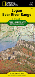
Trails Illustrated. We hesitate to refer users to a commercial product, but the 2014 National Geographic/Trails Illustrated map for the Logan Bear River Range is an excellent resource. Printed on waterproof material, this double-sided map covers the area from Porcupine Reservoir on the south to Mink Creek on the north and Bear Lake on the east to Brigham City on the west. Trails are well marked by type (motorized, wilderness, etc.), with mileages. The map scale is 1:75,000, great for trip planning and general orientation, but the map is not a replacement for the more detailed topographic maps for off-trail hiking and route-finding. This map is available in local stores and online.
Local Snowshoe Rentals, updated for 2025 (some also have cross-country skis):
- Al's Sporting Goods
- The
Sportsman
- Stokes Nature
Center 913 S. 100 W, Logan UT, reserve online
or email nature@logannature.org
- USU Outdoor Recreation Center
- Submit an additional rental source for this list
Butterflies
- Wasatch Butterflies (pdf), by Todd L. Stout of the Utah Bug Club, is an easy-to-use guide to local butterflies. Colorful photos show common butterflies found in Northern Utah’s Wasatch Canyons from early spring through early fall.
Wildflowers
- Mountain Plants of Northeastern Utah (pdf), published by Utah State University, describes common trees, shrubs, vines and wildflowers found in our area. Illustrated with black-and-white line drawings although the book is organized by flower color.
- Utahwildflowers.com,
by Scott Nichols, is a searchable online guide.
Users can see which wildflowers are in bloom by
month or they can search using any of several
criteria. Links are provided for other resources,
including books, websites and apps.This website
was down on 2/12/2025.
- Wildflowersearch.com,
by Steven.K.Sullivan, lets users search for plants
by location, flowering time, flower shape, color and
size.
Geology
- Utah Geological Survey "Survey Notes" features
"GeoSights" articles about Tony
Grove, Ricks
Spring and Wind
Cave
- The Utah Geological Survey's interactive "Geologic
Map Portal" allows users to zoom in and see
geologic unit details anywhere in Utah
Hunting
- Hikers should wear "hunter
orange" clothing for safety during rifle hunting
seasons for deer and elk.